Image

Restoring Ecological Diversity of Forests with Airborne Imaging Technologies (RED FAITH)
Published on 03 February 2021

Hungary
Dél-Dunántúl
This is the good practice's implementation level. It can be national, regional or local.
About this good practice
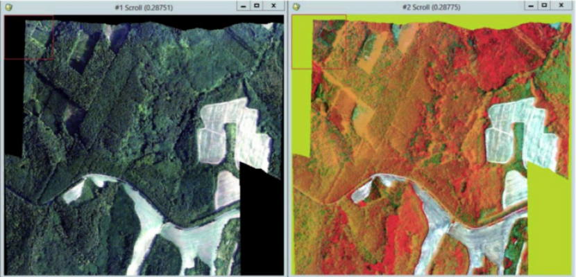
The project ‘Restoring Ecological Diversity of Forests with Airborne Imaging Technologies (RED FAITH)’ was financed by the HU-HR CBC Programme. Climate change adaptation and environmental protection are especially important in this region due to its remarkable natural values. Forest ecosystem services are not only valuable reserves of biodiversity and vital for recreation, but provide resources, biomass and offer employment in rural areas. The forest companies of the border region identified that monitoring of the forests is a first step to prevent invasive species and other endangering factors from spreading. The overall objective of the project is to provide forest companies and organizations responsible for managing habitats with a detailed, up-to-date monitoring system supported by airborne imaging. This accelerates reactions to emerging hazards, protects/restores natural assets by enabling forest companies to select more efficient interventions, improves knowledge of forest engineers, and raises awareness of forest values while providing financial benefits due to the technology used. Firstly, forest companies surveyed a total of 24,838 ha using airborne imaging technologies and defined parameters for monitoring. The pilot results allowed differentiation of species, calculating stocks, recognizing invasive species and diseases, etc. Integration of images into digital regional planning maps for energy and environment related investments was done by cooperating partners.
Expert opinion
The PROGRESS project proves once more effective in identifying good practices that could be replicated replicated in many EU regions to expand knowledge on the ecosystem services provided by forests and to better inform the decisions on the eradication of invasive alien species threatening their status. The technique outlined by the good practice at hand can be instrumental for attaining many of the policy objectives of the new EU 2030 Biodiversity Strategy. Local and regional authorities may certainly consider using drones and availing themselves of aerial imaging to design and implement measures for the sustainable management of forests and their restoration.
Resources needed
The total ERDF funding of the project was 48,401.94 EUR, covering 85% of the project’s expenditure. Further 15% was provided as own contribution.
Evidence of success
As a result of the project 3 hectares of infected forest areas were cleaned of invasive species using chemical and mechanical methods. Forest companies surveyed a total of 24,838 ha using airborne imaging, the technologies were also promoted amongst forestry experts and school pupils. Multimedia devices have been procured to introduce the natural values of forests for kids. The ecotourism conditions were improved on both sides of the border, and the public is better informed now.
Potential for learning or transfer
The results of pilot actions (aerial imaging of forest areas) can be discussed with Hungarian and Croatian forest companies, the evaluation of an experimental action can be downloaded and analysed for the local adaptation. After setting the goals for other regions – like creating a repository of species, identifying invasive species, detecting diseases of the vegetation – the applicable imaging technics can be selected, mixed tools can be defined. The expected costs of the airborne imaging and quality of images, potential obstacles, timeframes can be predicted from the experiences of the pilot action. With this support, the efficiency of monitoring of the European forest areas can be raised and databases can be unified.
Further information
Website
Good practice owner
You can contact the good practice owner below for more detailed information.
Organisation
Ministry for National Economy

Hungary
Dél-Dunántúl
Contact

Managing Director