Image
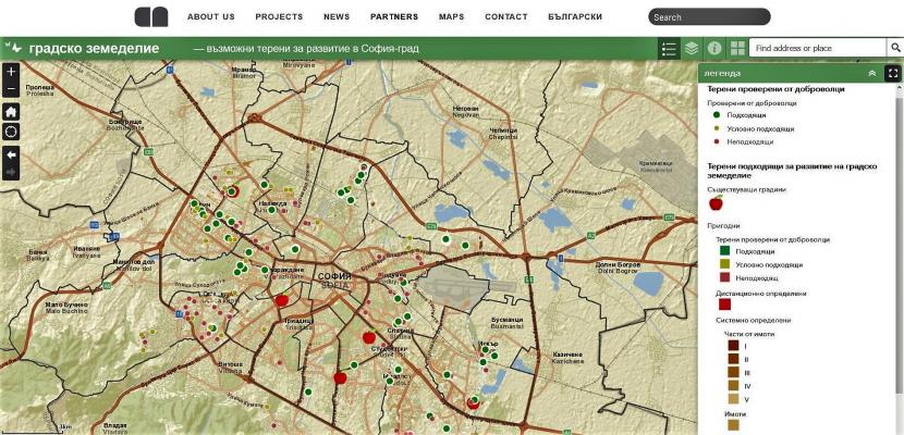
Digital map of city areas suitable for urban agriculture
Published on 15 December 2020

Bulgaria
Yugozapaden
This is the good practice's implementation level. It can be national, regional or local.
About this good practice
In order to illustrate potential areas for community-type urban gardens, a digital map was produced to support urban gardening initiatives and decision-making in Sofia. The map was designed by the municipal enterprise Sofiaplan (formerly named Sofproect), but the idea came from the CSO ‘Initiative for the Development of Urban Farming’ in Sofia, which participated actively in the process of data collection and validation of the terrains by the help of volunteers.
The map is seen as a crucial precondition for the launch and scale up of the community gardens in Sofia - a key mission of the ‘Initiative for the Development of Urban Farming.’ To date there was no systematic and public data on how many and which municipality-owned terrains could potentially be used for urban gardening. Hence, it was not possible to approach the municipality with a well-formulated and justified request for a long-term access (by rent or in other appropriate way) to these sites.
The map identifies, describes and evaluates the land plots that can be potentially used for urban gardening. This allows citizen groups and other organisations to address the relevant municipal services with inquiries to access these plots and use them to create urban gardens/farms.
Apart from citizens, the map also helps Sofia municipal authorities to streamline their urban development policies, especially in line with the municipal strategies for sustainable development – ‘Green Sofia and Vision for Sofia 2050.’
Expert opinion
This good practice is totally aligned with the objective of the Farm to Fork Strategy of transitioning towards sustainable food systems on the basis of a collective approach that also involves cities and communities. This digital map will indeed assist people in finding the right spot where to grow their vegetables in the city. Other municipalities in the EU can be inspired by the initiative undertaken in Sofia to identify existing plots suitable for urban gardening in their territories. As Sofia did, they should also use the digital map as a tool to facilitate the integration of farming into their long-term municipal strategies for sustainable development, including in the area of urban planning.
Resources needed
- desk research: analysis of Sofia General Urban Plan, classification of areas by using online tools (Google Maps, Earth and Street View, Copernicus database on landcover and vegetation
- field work: onsite assessment of shortlisted areas
- volunteers: CSOs and citizens interested in urban farming
- field work: onsite assessment of shortlisted areas
- volunteers: CSOs and citizens interested in urban farming
Evidence of success
The map was finished and published in Oct. 2020. It presents 65 municipally-owned properties suitable for urban farming and also shows the location of already existing six community gardens in Sofia.
The map is a key tool to convey the message on feasibility and benefits of urban gardening both to municipal authorities and potential urban gardening practitioners. It is a strong leverage for citizens and other interested groups to negotiate on plots for urban gardening with the municipality.
The map is a key tool to convey the message on feasibility and benefits of urban gardening both to municipal authorities and potential urban gardening practitioners. It is a strong leverage for citizens and other interested groups to negotiate on plots for urban gardening with the municipality.
Potential for learning or transfer
This digital map is a successful example of a win-win cooperation between the municipal administration and a civic initiative. The municipality received a compact and up-to-date descriptive map of land plots that can be used to revitalise less developed city areas and to elevate their socio-economic profile. The civil groups interested in urban gardening obtained a very clear idea about the scope and location of potential community gardens and thus are better prepared to negotiate the renting and other conditions with the municipality.
Regions and cities without a map or a detailed list of plots suitable for urban farming can easily transfer this good practice which not only emphasizes cooperation, but also voluntarism. Volunteers that support urban gardening have been actively involved in all on-site visits and validation of appropriate land plots.
Regions and cities without a map or a detailed list of plots suitable for urban farming can easily transfer this good practice which not only emphasizes cooperation, but also voluntarism. Volunteers that support urban gardening have been actively involved in all on-site visits and validation of appropriate land plots.
Further information
Website
Good practice owner
You can contact the good practice owner below for more detailed information.
Organisation
Sofiaplan (a municipal enterprise responsible for the spatial and strategic planning of Sofia Municipality)
Bulgaria
Yugozapaden
Contact
Senior Analyst