Home
Search
Help & contact
  • Help
    • FAQ
    • Legal notice & privacy policy
    • Accessibility
    • Anti-fraud policy
  • Contact
    • Contact form
    • Our team
    • National Point of Contact
    • Jobs and tenders
My account
  • Create new account
  • New website! you need to:Reset your password
  • Discover the programme
    Back

    About us

    • What is Interreg Europe ?
    • Facts and figures
    • Programme structure
    • 2014-2020 programme
    • Country specific info

    Programme actions

    • Image
      Projects
      Discover approved projects and be inspired
    • Image
      Policy Learning Platform
      Get policy advice and find solutions for your region

    Programme documents

    • Image
      Programme manual
    • Image
      Cooperation programme
    • Image
      Annual implementation report
    • Image
      Logo and branding guidelines

    Programme news

    Field of wheat
    Supporting the agrifood sector
    04 August 2022
    See all

    See also

    • Apply to next call
    • See project results
    • Find policy solutions
  • Look for funding
    Back

    Next call for projectsDiscover our terms of reference

    Country specific informationCheck your country rules

    Main navigation - Steps

    • Image
      1. Check project relevance
      Use our self-assessment tool
    • Image
      2. Get inspired
      See approved projects and project ideas
    • Image
      Now available!
      3. Share your project idea
      Explain what you want your project to achieve
    • Image
      4. Find partners
      Look for organisations that share your interests
    • Image
      5. Ask for feedback
      Obtain guidance before applying
    • Image
      Call closed
      6. Apply for the call
      Submit your project proposal

    Applicant news

    Field of wheat
    Supporting the agrifood sector
    04 August 2022
    See all

    See also

    • Project implementation guidance
    • Support & FAQs
  • Approved projects
    Back

    Approved projects

    Projects by topic: See all
    Image
    Smart
    Image
    Green
    Image
    Connected
    Image
    Social
    Image
    Citizens
    Image
    Governance
    Search approved projects by :
    Country(France, Italy, Germany...)

    Implement project

    • Programme manual
    • Guidance and templates
    • First level control

    Project results

    • Overview
      Latest programme achievements
    • Image
      Web documentary
      A set of video stories about project results

    Project news

    Field of wheat
    Supporting the agrifood sector
    04 August 2022

    See also

    • Facts and figures
    • Policy solutions
  • Get policy advice
    Back

    Our expert team

    The Policy Learning Platform consists of a team of Thematic Experts supporting practitioners and policymakers across Europe.
    More about the experts
    Discover the Platform

    Contact us

    Our policy learning services

    • Image
      Peer review
      Receive feedback from relevant peers during a two-day in-depth analysis. (for public authorities)
    • Image
      Matchmaking session
      Be inspired from good practices across Europe during a two-hour exchange
    • Image
      Policy helpdesk
      We provide answers to any type of questions you might have in regional policy-making

    Platform news

    Field of wheat
    Supporting the agrifood sector
    04 August 2022
    See all

    See also

    • People in our community
    • Policy solutions
    • Project funding
  • Find policy solutions
    Back

    Resources by topic

    See all
    Image
    Smart
    Image
    Green
    Image
    Connected
    Image
    Social
    Image
    Citizens
    Image
    Governance
    Search resources by :
    Country(France, Italy, Germany...)

    Resources by type

    • Good practices
      Don't miss!
      Tested and transferable solutions from approved projects
    • Stories
      Thematic articles about our good practices
    • Policy briefs
      Expert analyses of the Interreg Europe projects and topics
    • Event learnings
      Recordings and materials from our webinars and workshops
    • Expert support reports
      Reports from peer reviews and matchmaking sessions

    Thematic news

    Field of wheat
    Supporting the agrifood sector
    04 August 2022
    See all

    See also

    • Our policy advice
    • Project implementation guidance
  • Meet our community
    Back

    Connect with members

    Members by interests : See all
    Image
    Smart
    Image
    Green
    Image
    Connected
    Image
    Social
    Image
    Citizens
    Image
    Governance
    Search members by :
    Country(France, Italy, Germany...)

    Connect with

    • The Interreg Europe team
    • The Platform experts
    • The national points of contact

    Create an account

    Connect with like-minded people from all over Europe and:

    • Find cooperation partners
    • Follow their latest activities
    • Exchange good practices
    • Get personalised feed

    Read more

    Create account

    Community news

    Field of wheat
    Supporting the agrifood sector
    04 August 2022
    See all

    See also

    • Our policy advice
    • Projects ideas looking for partners
  1. Home
  2. Find policy solutions
  3. Good practices 
  4. Creating a GIS system which is based on modern remote sensing methods and satellite data
Image

Creating a GIS system which is based on modern remote sensing methods and satellite data

GreenBiodiversity preservation
By project PROSPERA
Published on 01 April 2021
Hungary
Gyula Dézsi
Urban development expert
See phone number Sign up to contact

Send an email

Gyula Dézsi

0036202418868
About text formats
You can upload up to 3 files with a storage duration limit of 2 weeks (from email reception date). Supported format: .pdf, .doc. docx. xls .xlsx . odt .ods . jpg .png. Maximum size : 10mo.

Send an email

Your mail has been sent !

This window will automatically close in 5s...

Close

About this good practice

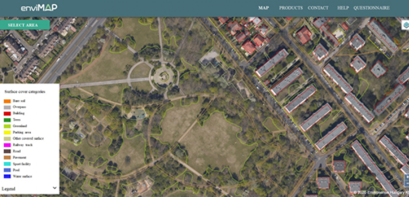
Post-socialist countries (thus Hungary) have undergone significant development since 1990, which affected our environment. Systems that form the basis of present-day urban and regional planning are outdated. To meet the challenges of the 21st century, municipalities/authorities need to set up new, modern methods. Based on remote sensing technology developed by Envirosense Hungary Ltd., the GIS system supports fact and data-based policy decision making.
This system could give an accurate picture of the actual state of green areas, urban spatial structure, building density etc. of a city. Time series analysis of satellite data show us how the urban structure has changed over time, thus trends can be identified, ongoing processes can be monitored. In the GIS system the spatial is complemented with attributive data (e.g. demography, POIs and institution locations, public transport network data, etc.) that gives the basis of several spatial analyses.
Having such a database which integrates existing city development and urban management data enables to gain exact information of the values and economic activities of peri-urban areas. These data are important to set the goals of a sustainable development strategy.
Envirosense Hungary Ltd. observed several major Hungarian cities and built up databases that have been contributing factors in urban planning and development (e.g. Budapest, Kecskemét, Érd etc.). Envirosense Hungary Ltd. operates in Debrecen.
Sign up to see the expert opinion

Resources needed

Envirosense Hungary Ltd. can provide data processing and building the GIS database: 1 p. for support and helpdesk . Maintaining the system requires additional manpower from the municipalities: 2 p. from the municipality for system operation.
Monthly licence fee: 1500 EUR

Evidence of success

1. Data-driven technology 2. Skilled experts.
3. R&D background; connection with the Univ. of Debrecen 4. Existing GIS systems in 12 Hungarian cities (including Debrecen)
5. The data has geodetic accuracy, environmental processes can be measured.
The technology used is up to date and constantly evolving.
Targets where remote sensing data and GIS have been applied after presenting the system in Debrecen: green cadastre, chimney cadastre, cemetery cadastre, online regulation plan

Potential for learning or transfer

The success of using remote sensing data in decision making stands or falls on the transfer of information.By generating easy-to-understand information products, remote sensing become more tangible.Online platforms, map services where data can be filtered, analysed are great tools to support decision making.Although, aerial remote sensing data is not available for each area, satellite data that covers larger areas can be widely used for several analyses.Data processing routines are already developed they just have to be adapted to any certain area of interest.Municipality of Debrecen is committed to develop a GIS based decision support system, where all data will be channelled step by step to a database and online platform.The development of the system is already ongoing and the built framework is suitable to handle data for any municipality.Moreover, the flexibility of the framework gives the possibility for the implementation of new functions that are important for decision makers.

Further information

Website

Website

Good practice owner

Organisation

Envirosense Hungary Ltd.

Hungary
Észak-Alföld
Contact
Gyula Dézsi
Urban development expert
See phone number Sign up to contact

Send an email

Gyula Dézsi

0036202418868
About text formats
You can upload up to 3 files with a storage duration limit of 2 weeks (from email reception date). Supported format: .pdf, .doc. docx. xls .xlsx . odt .ods . jpg .png. Maximum size : 10mo.

Send an email

Your mail has been sent !

This window will automatically close in 5s...

Close
Tags
Analysis
Data
Mapping
Planning
Summary

    Share

    Creating a GIS system which is based on modern remote sensing methods and satellite data https://www.interregeurope.eu/good-practices/creating-a-gis-system-which-is-based-on-modern-remote-sensing-methods-and-satellite-data
    Facebook Twitter Linkedin

    Similar good practices

    See all good practices
    Image
    Good practice - Green
    2014 - 2020

    Tralee Bay Wetlands Eco and Activity Park

    The Tralee Bay Wetlands Eco & Activity Park is an innovative and sustainable visitor attraction designed to be a microcosm of the nature reserve it adjoins.
    27 Jan 2022 | By project Blue Green City
    Expert approved
    Image
    2014 - 2020

    Eco tourism - a sustainable chain

    We created a network of companies in order to support each other and together strengthen the sustainable chain that is eco tourism.
    20 Jan 2022 | By project WLE
    Expert approved
    Image
    Good practice - Green
    2014 - 2020

    Monitoring

    Knowledge is power and measurement is the key to knowledge. Only once you know how people behave, you can make the correct conclusions and act upon them.
    20 Jan 2022 | By project WLE
    Expert approved
    Image
    2014 - 2020

    Involving citizens through hybrid participation formats

    The hybrid design of citizens participation is both digital and on the spot. It allows to capture a broad variety of community views.
    19 Jan 2022 | By project Blue Green City
    Expert approved
    Image
    2014 - 2020

    “Luxus der Leere” in the Altmark region

    "Luxus der Leere" is a joint initiative of municipalities in the Altmark region for the development of more sustainable settlement structures.
    19 Jan 2022 | By project RENATUR
    Expert approved
    Image
    2014 - 2020

    Viticulture Impact Assessment on the Environment (VIVA)

    Product’s footprint and company’s environmental, social and economic impact supported by capacity building initiatives on sustainability in the supply chain.
    13 Jan 2022 | By project LCA4Regions
    Expert approved
    Image
    2014 - 2020

    Methods and tools for developing a sustainable landscape plan for the metropolitan area

    Multiscale analysis based on landscape ecology, ES, vulnerabilty and resilience used to integrate landscape complexity in a Green and Blue Infrastructure plan
    21 Dec 2021 | By project Blue Green City
    Expert approved
    Image
    2014 - 2020

    Wines of Alentejo Sustainability programme - WASP

    A programme to support economic agents in improving the environmental, social and economic performance of the region's winegrowing activity.
    10 Dec 2021 | By project LCA4Regions
    Expert approved

    Contact us

    • Our team
    • Points of contact
    • Jobs & tenders
    • Contact form

    Help

    • FAQ
    • COVID-19
    • Branding guidelines

    Key links

    • List of operations
    • List of calls
    • L'Europe s'engage
    • European Commission

    Join the community

    • Meet new people and find partners
    • Join our events: in person and online
    • Receive personalised content
    • Exchange good practices

    Join the community

    Home

    Footer

    • Legal
    • Cookies
    • Help
    • Accessibility
    • Privacy Policy